At last a couple of decent days for the landscape photographer! On Wednesday I headed down to Merthyr Tydfil, an unloved town situated just outside Brecon Beacons National Park; outside it for very good reason. It is no exaggeration to say that the countryside surrounding Merthyr has been ravaged by the coal, iron and steel industries. While heavy industry is in terminal decline, and much of the devastation been discretely landscaped away, it is still the location of the one of largest open-cast coal quarries in Europe. Why on earth would I want to spend an absolute gem of an autumn day in a place like this, you are probably wondering….
There was an explosion of coal-mining and other heavy industry in the South Wales Valleys in the nineteenth and twentieth centuries. The “Valleys” were, in effect, a sacrifice zone at the root of the industrial revolution, with absolutely no thought at all given the environment. Rapid population growth led to the construction of countless towns and villages, strung out along steep valley sides and valley bottoms, with roads and railways to link them together. Today’s Valleys are tidy enough visually but fifty years ago they would have been very different; and to be honest, as a photographer, I would like to be transported back in time to be able to document them…….. but I digress. There is one exception to this picture of destruction and rehabilitation: a two-mile section of a tributary of the Taff – and a fairly major one at that. No roads run through it, and strangely, no public footpaths. The only sign of development is a single-track railway line which now carries away trainloads of coal from the Ffos-y-fran opencast site near Merthyr. Signs of agriculture in the valley are few and far between; it may have been farmed at one time but it certainly isn’t now. The valley is a complete anachronism.
I discovered the Bargoed Taf (a.k.a. Cwm Bargoed) while I was working on my first book – “Wales – the Lie of the Land“. I must have been poring over an Ordnance Survey map of the area when I noticed the tell-tale signs of unimproved land – patches of unfenced woodland dotted around the landscape fairly randomly. I visited it in spring 1995 and a photograph appears in the book, which was published the following year. In my notes (p107), I wrote
“Cwm Bargoed lies just a few miles south-east of Merthyr Tydfil, arguably the cradle of the industrial revolution in Wales. But with its extensive alder and other woodland, and its lightly grazed grassland it recalls a pre-industrial era in “the Valleys”. Astonishingly, it receives no protection under the Wildlife and Countryside Act; one change of ownership and we could lose this gem to agricultural ‘improvement’……. Surely the open-cast coal industry has its greedy eyes on this pristine landscape too.”
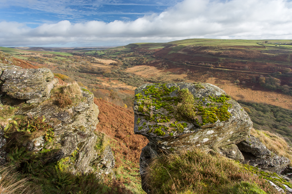
More than twenty years later I went back to Cwm Bargoed, and it is still breathtaking. Nothing has changed since my first visit and the valley would not be out of place in any National Park anywhere in the world. You can see this from the photograph above, and please note – I have not hidden a factory or housing estate behind the rock feature in the foreground! It might sound a bit conventional, but I thought the image needed a bit of foreground interest. The really eagle-eyed might pick out Cwm Bargoed coal washery just below the horizon to the left of centre. It is to here that the coal is brought by dump-truck from Ffos-y-fran for processing and loading on to trains. It is actually about 2.5 miles away but the 17mm focal length I used here makes it look much more distant.

The lower photograph, taken on a different visit, shows the washery in all its glory, plus a new addition – a solar array – the power from which is used to clean up the discharge from another old colliery a few miles downstream. In the background are dumps of overburden removed from Ffos-y-fran. It represents a very confusing picture of energy policy in this country – or alternatively – an accurate picture of a very confusing energy policy…….
I have spent quite some time on the internet searching for information about Cwm Bargoed. The coal plant features quite strongly, as does the railway line, and a country park created by a mine reclamation project a few miles to the south. Nobody else, it seems, has photographed it either. Cwm Bargoed has no special protection. With its cloak of native grassland and woodland, and the lack of any human activity, it is almost as if it has become invisible.
Edit: in 1995 a small “one-man-and-his-dog” private coal mine was still in operation alongside the railway line, and I also used a photograph of that in Wales – the Lie of the Land. Like all such mines, it is now closed.
To follow Tales from Wild Wales, please scroll down to the bottom and click Follow .